


Celles sur Ource

MoiClaude
User
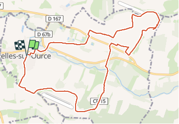

Length
12.4 km

Max alt
280 m

Uphill gradient
287 m
Km-Effort
16.2 km

Min alt
156 m

Downhill gradient
283 m
Boucle
Yes
Creation date :
2023-07-20 12:28:27.436
Updated on :
2023-07-20 15:27:25.072
2h54
Difficulty : Difficult

FREE GPS app for hiking
 SityTrail
IGN / Geographical institutes
SityTrail Plus
The world is yours!
About
Trail Walking of 12.4 km to be discovered at Grand Est, Aube, Celles-sur-Ource. This trail is proposed by MoiClaude.
Description
Super randonnée dans les vignes.
Positioning
Country:
France
Region :
Grand Est
Department/Province :
Aube
Municipality :
Celles-sur-Ource
Location:
Unknown
Start:(Dec)
Start:(UTM)
604411 ; 5325748 (31U) N.
Comments