


qwadrifyon entre la rock, sparmont et bloquay

stef789
User GUIDE
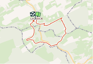

Length
6.6 km

Max alt
268 m

Uphill gradient
165 m
Km-Effort
8.8 km

Min alt
144 m

Downhill gradient
166 m
Boucle
Yes
Creation date :
2023-07-21 13:13:15.857
Updated on :
2023-07-21 15:26:12.026
2h12
Difficulty : Medium

FREE GPS app for hiking
 SityTrail
IGN / Geographical institutes
SityTrail Plus
The world is yours!
About
Trail Walking of 6.6 km to be discovered at Wallonia, Liège, Anthisnes. This trail is proposed by stef789.
Photos


Positioning
Country:
Belgium
Region :
Wallonia
Department/Province :
Liège
Municipality :
Anthisnes
Location:
Unknown
Start:(Dec)
Start:(UTM)
678395 ; 5593346 (31U) N.
Comments