


on LUI a consacré une heure, on ne L´a jamais trouvé

stef789
User GUIDE
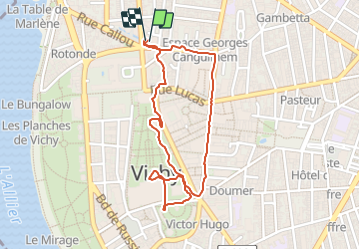

Length
2.1 km

Max alt
265 m

Uphill gradient
17 m
Km-Effort
2.3 km

Min alt
256 m

Downhill gradient
18 m
Boucle
Yes
Creation date :
2023-07-23 20:32:58.56
Updated on :
2023-07-23 21:34:03.382
1h00
Difficulty : Easy

FREE GPS app for hiking
 SityTrail
IGN / Geographical institutes
SityTrail Plus
The world is yours!
About
Trail Walking of 2.1 km to be discovered at Auvergne-Rhône-Alpes, Allier, Vichy. This trail is proposed by stef789.
Photos


Positioning
Country:
France
Region :
Auvergne-Rhône-Alpes
Department/Province :
Allier
Municipality :
Vichy
Location:
Unknown
Start:(Dec)
Start:(UTM)
532453 ; 5108341 (31T) N.
Comments