


Cantal - étape 2 - Font de Cère-St Jacques des Blats - 23 juillet 2023

morganee
User
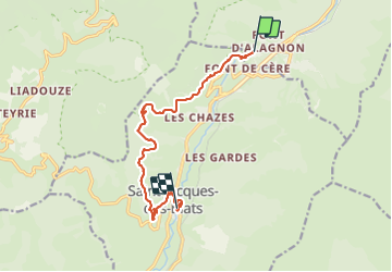

Length
11.4 km

Max alt
1355 m

Uphill gradient
246 m
Km-Effort
15.7 km

Min alt
966 m

Downhill gradient
556 m
Boucle
No
Creation date :
2023-07-23 08:46:07.916
Updated on :
2023-07-24 07:04:33.469
5h26
Difficulty : Easy

FREE GPS app for hiking
 SityTrail
IGN / Geographical institutes
SityTrail Plus
The world is yours!
About
Trail Walking of 11.4 km to be discovered at Auvergne-Rhône-Alpes, Cantal, Laveissière. This trail is proposed by morganee.
Positioning
Country:
France
Region :
Auvergne-Rhône-Alpes
Department/Province :
Cantal
Municipality :
Laveissière
Location:
Unknown
Start:(Dec)
Start:(UTM)
479260 ; 4992576 (31T) N.
Comments