


le col du Guery lac Servières les Planchettes

jeanic63
User
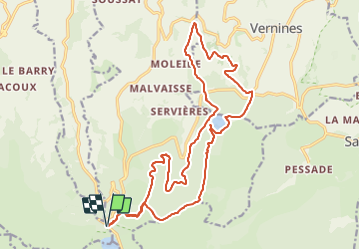

Length
22 km

Max alt
1486 m

Uphill gradient
747 m
Km-Effort
32 km

Min alt
989 m

Downhill gradient
746 m
Boucle
Yes
Creation date :
2023-07-24 16:19:35.285
Updated on :
2023-07-24 16:34:47.86
7h14
Difficulty : Difficult

FREE GPS app for hiking
 SityTrail
IGN / Geographical institutes
SityTrail Plus
The world is yours!
About
Trail On foot of 22 km to be discovered at Auvergne-Rhône-Alpes, Puy-de-Dôme, Orcival. This trail is proposed by jeanic63.
Description
départ parking col du Guery ATTENTION nouveau tracé du GR 30
Positioning
Country:
France
Region :
Auvergne-Rhône-Alpes
Department/Province :
Puy-de-Dôme
Municipality :
Orcival
Location:
Unknown
Start:(Dec)
Start:(UTM)
486005 ; 5051965 (31T) N.
Comments