


Narreyroux crête de Reychard

CABERMAT
User
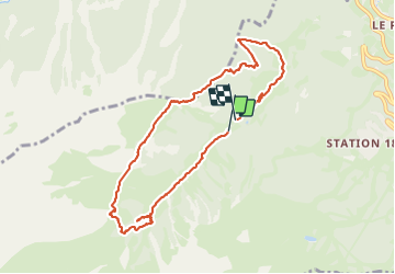

Length
9.2 km

Max alt
2260 m

Uphill gradient
552 m
Km-Effort
16.6 km

Min alt
1726 m

Downhill gradient
567 m
Boucle
Yes
Creation date :
2023-07-01 08:01:20.859
Updated on :
2023-07-24 17:30:50.157
3h30
Difficulty : Difficult

FREE GPS app for hiking
 SityTrail
IGN / Geographical institutes
SityTrail Plus
The world is yours!
About
Trail Walking of 9.2 km to be discovered at Provence-Alpes-Côte d'Azur, Hautes-Alpes, Puy-Saint-Vincent. This trail is proposed by CABERMAT.
Positioning
Country:
France
Region :
Provence-Alpes-Côte d'Azur
Department/Province :
Hautes-Alpes
Municipality :
Puy-Saint-Vincent
Location:
Unknown
Start:(Dec)
Start:(UTM)
299160 ; 4965993 (32T) N.
Comments