


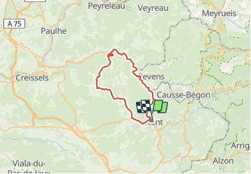
Nant-Roque Ste Marguerite -Pierrefiche

ericferon
User

Length
43 km

Max alt
854 m

Uphill gradient
790 m
Km-Effort
53 km

Min alt
399 m

Downhill gradient
793 m
Boucle
No
Creation date :
2023-07-26 10:40:45.748
Updated on :
2023-07-26 14:25:57.978
3h32
Difficulty : Difficult
3h00
Difficulty : Medium

FREE GPS app for hiking
 SityTrail
IGN / Geographical institutes
SityTrail Plus
The world is yours!
About
Trail Road bike of 43 km to be discovered at Occitania, Aveyron, Nant. This trail is proposed by ericferon.
Description
Gorges de la Fournir et plateau du Larzac
Positioning
Country:
France
Region :
Occitania
Department/Province :
Aveyron
Municipality :
Nant
Location:
Unknown
Start:(Dec)
Start:(UTM)
523738 ; 4874471 (31T) N.
Comments