


Puy Mary par la brèche de Roland depuis le Buron d'Eylac en boucle - 27 juillet 2023

morganee
User
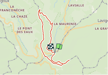

Length
17 km

Max alt
1767 m

Uphill gradient
838 m
Km-Effort
28 km

Min alt
1288 m

Downhill gradient
844 m
Boucle
Yes
Creation date :
2023-07-27 06:16:20.084
Updated on :
2023-07-27 17:36:49.08
8h04
Difficulty : Medium

FREE GPS app for hiking
 SityTrail
IGN / Geographical institutes
SityTrail Plus
The world is yours!
About
Trail Walking of 17 km to be discovered at Auvergne-Rhône-Alpes, Cantal, Lavigerie. This trail is proposed by morganee.
Description
Le passage par la brèche de Roland dans ce sens est plus simple que dans l'autre sens.
Positioning
Country:
France
Region :
Auvergne-Rhône-Alpes
Department/Province :
Cantal
Municipality :
Lavigerie
Location:
Unknown
Start:(Dec)
Start:(UTM)
475326 ; 4995458 (31T) N.
Comments