


Maron-Scy Chazelles

nicolas54230
User
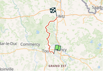

Length
86 km

Max alt
357 m

Uphill gradient
1216 m
Km-Effort
102 km

Min alt
161 m

Downhill gradient
1230 m
Boucle
No
Creation date :
2023-07-27 17:43:39.134
Updated on :
2023-07-27 17:45:30.881
0m
Difficulty : Difficult

FREE GPS app for hiking
 SityTrail
IGN / Geographical institutes
SityTrail Plus
The world is yours!
About
Trail Cycle of 86 km to be discovered at Grand Est, Meurthe-et-Moselle, Maron. This trail is proposed by nicolas54230.
Positioning
Country:
France
Region :
Grand Est
Department/Province :
Meurthe-et-Moselle
Municipality :
Maron
Location:
Unknown
Start:(Dec)
Start:(UTM)
282416 ; 5391090 (32U) N.
Comments