


flattach

phil21
User
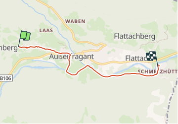

Length
4.9 km

Max alt
897 m

Uphill gradient
48 m
Km-Effort
6.2 km

Min alt
692 m

Downhill gradient
248 m
Boucle
No
Creation date :
2023-07-28 13:53:04.939
Updated on :
2023-07-28 14:30:43.727
37m
Difficulty : Easy

FREE GPS app for hiking
 SityTrail
IGN / Geographical institutes
SityTrail Plus
The world is yours!
About
Trail Mountain bike of 4.9 km to be discovered at Carinthia, Bezirk Spittal an der Drau, Flattach. This trail is proposed by phil21.
Positioning
Country:
Austria
Region :
Carinthia
Department/Province :
Bezirk Spittal an der Drau
Municipality :
Flattach
Location:
Unknown
Start:(Dec)
Start:(UTM)
354479 ; 5199941 (33T) N.
Comments