


montferrer . El castel . Puiq de volafort .. retour par la piste

stef789
User GUIDE
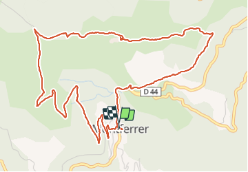

Length
7.5 km

Max alt
1121 m

Uphill gradient
330 m
Km-Effort
11.9 km

Min alt
788 m

Downhill gradient
334 m
Boucle
Yes
Creation date :
2023-07-28 11:38:55.996
Updated on :
2023-07-28 15:01:05.509
3h21
Difficulty : Easy

FREE GPS app for hiking
 SityTrail
IGN / Geographical institutes
SityTrail Plus
The world is yours!
About
Trail Walking of 7.5 km to be discovered at Occitania, Pyrénées-Orientales, Montferrer. This trail is proposed by stef789.
Photos


Positioning
Country:
France
Region :
Occitania
Department/Province :
Pyrénées-Orientales
Municipality :
Montferrer
Location:
Unknown
Start:(Dec)
Start:(UTM)
464400 ; 4698488 (31T) N.
Comments