


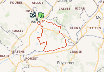
PR vazerac boucle

Glurps
User

Length
12.8 km

Max alt
176 m

Uphill gradient
175 m
Km-Effort
15.1 km

Min alt
92 m

Downhill gradient
173 m
Boucle
Yes
Creation date :
2023-07-14 07:52:12.0
Updated on :
2023-07-30 07:57:50.168
3h31
Difficulty : Easy

FREE GPS app for hiking
 SityTrail
IGN / Geographical institutes
SityTrail Plus
The world is yours!
About
Trail Walking of 12.8 km to be discovered at Occitania, Tarn-et-Garonne, Vazerac. This trail is proposed by Glurps.
Positioning
Country:
France
Region :
Occitania
Department/Province :
Tarn-et-Garonne
Municipality :
Vazerac
Location:
Unknown
Start:(Dec)
Start:(UTM)
362946 ; 4894450 (31T) N.
Comments