


Boucle entre Chirens et Macherin - 30 juillet 2023

morganee
User
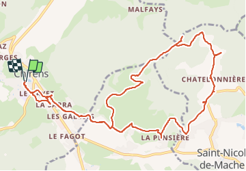

Length
15.8 km

Max alt
891 m

Uphill gradient
562 m
Km-Effort
23 km

Min alt
470 m

Downhill gradient
562 m
Boucle
Yes
Creation date :
2023-07-30 07:55:50.406
Updated on :
2023-07-30 14:44:34.617
5h17
Difficulty : Medium

FREE GPS app for hiking
 SityTrail
IGN / Geographical institutes
SityTrail Plus
The world is yours!
About
Trail Walking of 15.8 km to be discovered at Auvergne-Rhône-Alpes, Isère, Chirens. This trail is proposed by morganee.
Positioning
Country:
France
Region :
Auvergne-Rhône-Alpes
Department/Province :
Isère
Municipality :
Chirens
Location:
Unknown
Start:(Dec)
Start:(UTM)
699963 ; 5031935 (31T) N.
Comments