


Troyes nord

DaVinci
User
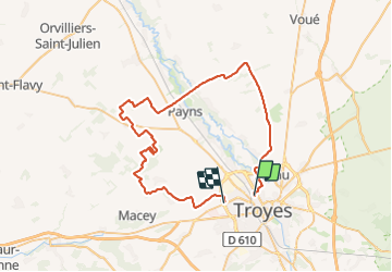

Length
57 km

Max alt
271 m

Uphill gradient
689 m
Km-Effort
66 km

Min alt
87 m

Downhill gradient
683 m
Boucle
No
Creation date :
2023-07-30 13:46:59.781
Updated on :
2023-07-30 15:23:35.081
1h36
Difficulty : Medium

FREE GPS app for hiking
 SityTrail
IGN / Geographical institutes
SityTrail Plus
The world is yours!
About
Trail Moto cross of 57 km to be discovered at Grand Est, Aube, Troyes. This trail is proposed by DaVinci.
Positioning
Country:
France
Region :
Grand Est
Department/Province :
Aube
Municipality :
Troyes
Location:
Unknown
Start:(Dec)
Start:(UTM)
578880 ; 5351240 (31U) N.
Comments