


Le bousquet

jbo1
User
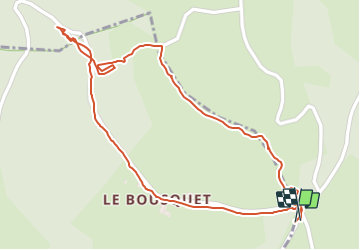

Length
1.5 km

Max alt
739 m

Uphill gradient
54 m
Km-Effort
2.2 km

Min alt
684 m

Downhill gradient
51 m
Boucle
Yes
Creation date :
2023-07-31 05:42:28.3
Updated on :
2023-07-31 06:15:07.706
34m
Difficulty : Easy

FREE GPS app for hiking
 SityTrail
IGN / Geographical institutes
SityTrail Plus
The world is yours!
About
Trail Walking of 1.5 km to be discovered at Occitania, Aveyron, Saint-Laurent-d'Olt. This trail is proposed by jbo1.
Description
À travers les prairies car une partie du chemin inexistant
Positioning
Country:
France
Region :
Occitania
Department/Province :
Aveyron
Municipality :
Saint-Laurent-d'Olt
Location:
Unknown
Start:(Dec)
Start:(UTM)
510879 ; 4922527 (31T) N.
Comments