


Andenne-2023-07-projet

guy284
User
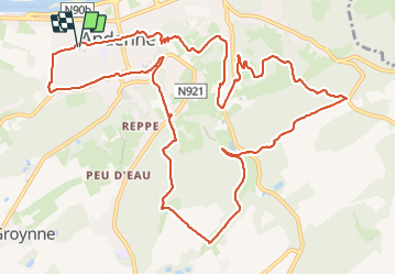

Length
13.8 km

Max alt
225 m

Uphill gradient
358 m
Km-Effort
18.5 km

Min alt
73 m

Downhill gradient
358 m
Boucle
Yes
Creation date :
2023-07-31 07:38:11.725
Updated on :
2023-07-31 07:39:05.028
4h12
Difficulty : Difficult

FREE GPS app for hiking
 SityTrail
IGN / Geographical institutes
SityTrail Plus
The world is yours!
About
Trail Walking of 13.8 km to be discovered at Wallonia, Namur, Andenne. This trail is proposed by guy284.


Positioning
Country:
Belgium
Region :
Wallonia
Department/Province :
Namur
Municipality :
Andenne
Location:
Unknown
Start:(Dec)
Start:(UTM)
648303 ; 5595049 (31U) N.
Comments