


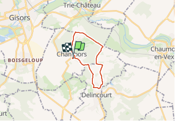
Chambord marche nordique

LE-BRASSEUR
User

Length
8.6 km

Max alt
151 m

Uphill gradient
162 m
Km-Effort
10.7 km

Min alt
64 m

Downhill gradient
160 m
Boucle
Yes
Creation date :
2023-07-31 06:05:57.251
Updated on :
2023-07-31 16:07:30.174
2h14
Difficulty : Very easy

FREE GPS app for hiking
 SityTrail
IGN / Geographical institutes
SityTrail Plus
The world is yours!
About
Trail Nordic walking of 8.6 km to be discovered at Hauts-de-France, Oise, Chambors. This trail is proposed by LE-BRASSEUR.
Description
DEPART ECOLE
Positioning
Country:
France
Region :
Hauts-de-France
Department/Province :
Oise
Municipality :
Chambors
Location:
Unknown
Start:(Dec)
Start:(UTM)
413841 ; 5457105 (31U) N.
Comments