


Pr2 saint cirq

Glurps
User
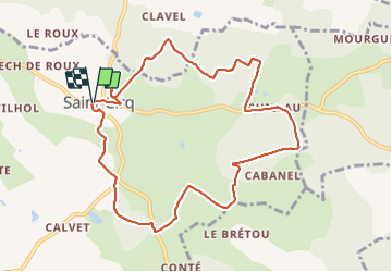

Length
10.4 km

Max alt
212 m

Uphill gradient
156 m
Km-Effort
12.5 km

Min alt
151 m

Downhill gradient
157 m
Boucle
Yes
Creation date :
2023-07-31 08:25:35.0
Updated on :
2023-07-31 11:01:07.412

FREE GPS app for hiking
 SityTrail
IGN / Geographical institutes
SityTrail Plus
The world is yours!
About
Trail of 10.4 km to be discovered at Occitania, Tarn-et-Garonne, Saint-Cirq. This trail is proposed by Glurps.
Positioning
Country:
France
Region :
Occitania
Department/Province :
Tarn-et-Garonne
Municipality :
Saint-Cirq
Location:
Unknown
Start:(Dec)
Start:(UTM)
388333 ; 4888998 (31T) N.
Comments