


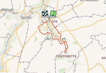
Vallée de L’ECLIMONT

gentileadriano
User

Length
11 km

Max alt
139 m

Uphill gradient
181 m
Km-Effort
13.5 km

Min alt
77 m

Downhill gradient
181 m
Boucle
Yes
Creation date :
2023-07-31 14:05:21.0
Updated on :
2023-07-31 14:05:22.722
3h03
Difficulty : Very easy

FREE GPS app for hiking
 SityTrail
IGN / Geographical institutes
SityTrail Plus
The world is yours!
About
Trail Walking of 11 km to be discovered at Ile-de-France, Essonne, Fontaine-la-Rivière. This trail is proposed by gentileadriano.
Positioning
Country:
France
Region :
Ile-de-France
Department/Province :
Essonne
Municipality :
Fontaine-la-Rivière
Location:
Unknown
Start:(Dec)
Start:(UTM)
437330 ; 5356319 (31U) N.
Comments