


le Beaucet-Saint Jean

micheldutilleul
User
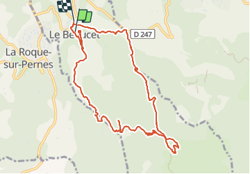

Length
11.9 km

Max alt
495 m

Uphill gradient
444 m
Km-Effort
17.9 km

Min alt
220 m

Downhill gradient
472 m
Boucle
No
Creation date :
2023-07-28 08:56:23.653
Updated on :
2023-08-01 15:52:17.056
3h30
Difficulty : Medium

FREE GPS app for hiking
 SityTrail
IGN / Geographical institutes
SityTrail Plus
The world is yours!
About
Trail Walking of 11.9 km to be discovered at Provence-Alpes-Côte d'Azur, Vaucluse, Le Beaucet. This trail is proposed by micheldutilleul.
Description
Magnifique balade dans les bois, mais très ensoleillée. Pas mal de passages sur les crêtes.
Elle est relativement physique.
Positioning
Country:
France
Region :
Provence-Alpes-Côte d'Azur
Department/Province :
Vaucluse
Municipality :
Le Beaucet
Location:
Unknown
Start:(Dec)
Start:(UTM)
669946 ; 4872213 (31T) N.
Comments