


pic Morgon savignes

Titinechris
User
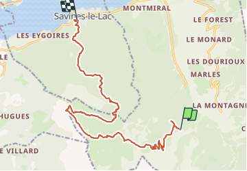

Length
18.6 km

Max alt
2311 m

Uphill gradient
1018 m
Km-Effort
35 km

Min alt
805 m

Downhill gradient
1758 m
Boucle
No
Creation date :
2023-08-02 06:57:26.71
Updated on :
2023-08-02 06:57:44.916
4h00
Difficulty : Medium

FREE GPS app for hiking
 SityTrail
IGN / Geographical institutes
SityTrail Plus
The world is yours!
About
Trail Trail of 18.6 km to be discovered at Provence-Alpes-Côte d'Azur, Hautes-Alpes, Crots. This trail is proposed by Titinechris.
Positioning
Country:
France
Region :
Provence-Alpes-Côte d'Azur
Department/Province :
Hautes-Alpes
Municipality :
Crots
Location:
Unknown
Start:(Dec)
Start:(UTM)
297559 ; 4928894 (32T) N.
Comments