


ste_Catherine

d.rognon
User

Length
10.4 km

Max alt
864 m

Uphill gradient
316 m
Km-Effort
14.6 km

Min alt
671 m

Downhill gradient
316 m
Boucle
Yes
Creation date :
2016-03-09 00:00:00.0
Updated on :
2016-03-09 00:00:00.0
3h07
Difficulty : Unknown

FREE GPS app for hiking
 SityTrail
IGN / Geographical institutes
SityTrail Plus
The world is yours!
About
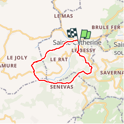
Trail Walking of 10.4 km to be discovered at Auvergne-Rhône-Alpes, Rhône, Sainte-Catherine. This trail is proposed by d.rognon.
Positioning
Country:
France
Region :
Auvergne-Rhône-Alpes
Department/Province :
Rhône
Municipality :
Sainte-Catherine
Location:
Unknown
Start:(Dec)
Start:(UTM)
622537 ; 5050501 (31T) N.
Comments