


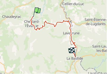
Les hauts de cheylard /Bastide puy Laurent

Nathalie. Mercier
User

Length
24 km

Max alt
1250 m

Uphill gradient
550 m
Km-Effort
32 km

Min alt
969 m

Downhill gradient
700 m
Boucle
No
Creation date :
2023-08-03 05:42:27.297
Updated on :
2023-08-03 13:51:37.605
6h11
Difficulty : Medium

FREE GPS app for hiking
 SityTrail
IGN / Geographical institutes
SityTrail Plus
The world is yours!
About
Trail Walking of 24 km to be discovered at Occitania, Lozère, Cheylard-l'Évêque. This trail is proposed by Nathalie. Mercier.
Description
Etape 4
très beau chemin très peu de goudron
2 déviations le 1er causse éboulement, le 2 ème construction d une passerelle
Photos


Positioning
Country:
France
Region :
Occitania
Department/Province :
Lozère
Municipality :
Cheylard-l'Évêque
Location:
Unknown
Start:(Dec)
Start:(UTM)
564052 ; 4945303 (31T) N.
Comments