


2023 08 08 Marat

chlafaille
User
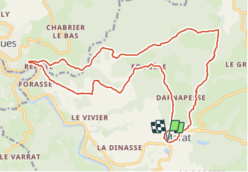

Length
12.9 km

Max alt
686 m

Uphill gradient
436 m
Km-Effort
18.7 km

Min alt
445 m

Downhill gradient
433 m
Boucle
Yes
Creation date :
2023-08-08 11:49:07.571
Updated on :
2023-08-08 14:58:56.598
3h08
Difficulty : Medium

FREE GPS app for hiking
 SityTrail
IGN / Geographical institutes
SityTrail Plus
The world is yours!
About
Trail Walking of 12.9 km to be discovered at Auvergne-Rhône-Alpes, Puy-de-Dôme, Marat. This trail is proposed by chlafaille.
Positioning
Country:
France
Region :
Auvergne-Rhône-Alpes
Department/Province :
Puy-de-Dôme
Municipality :
Marat
Location:
Unknown
Start:(Dec)
Start:(UTM)
553006 ; 5056323 (31T) N.
Comments