


pic d'Antenac depuis St Paul d'Oueil

cl56
User
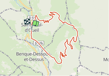

Length
12 km

Max alt
1757 m

Uphill gradient
774 m
Km-Effort
22 km

Min alt
1014 m

Downhill gradient
764 m
Boucle
Yes
Creation date :
2023-08-08 11:57:31.7
Updated on :
2023-08-08 18:21:47.608
6h06
Difficulty : Medium

FREE GPS app for hiking
 SityTrail
IGN / Geographical institutes
SityTrail Plus
The world is yours!
About
Trail Walking of 12 km to be discovered at Occitania, Haute-Garonne, Saint-Paul-d'Oueil. This trail is proposed by cl56.
Positioning
Country:
France
Region :
Occitania
Department/Province :
Haute-Garonne
Municipality :
Saint-Paul-d'Oueil
Location:
Unknown
Start:(Dec)
Start:(UTM)
299800 ; 4744536 (31T) N.
Comments