


Etape 10 St Étienne vallée française/St Jean du gard

Nathalie. Mercier
User
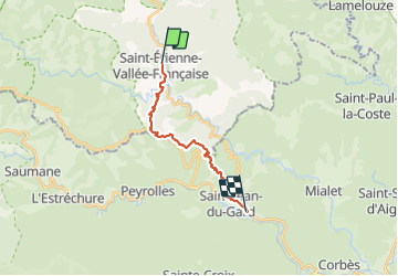


4h37
Difficulty : Difficult

FREE GPS app for hiking
 SityTrail
IGN / Geographical institutes
SityTrail Plus
The world is yours!
About
Trail Walking of 15 km to be discovered at Occitania, Lozère, Saint-Étienne-Vallée-Française. This trail is proposed by Nathalie. Mercier.
Description
Attention Nouveau GR depuis 2 ans non mentionné sur le topo guide 2023 ni même le livret de stevenson 2023
au col de St Pierre il faut traverser la route en plein virage chemin très escarpé raide montée et descente difficile après toutes ces étapes cumulées attention pour ceux qui ont les genoux et chevilles fragiles prenez l ancien tracé qui sera beaucoup moins difficile , .pour les sportifs vous allez vous regaler
Photos


Positioning
Comments