


2023 08 10 col de la loge

chlafaille
User
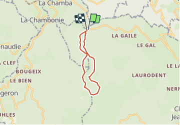

Length
9.3 km

Max alt
1347 m

Uphill gradient
180 m
Km-Effort
11.7 km

Min alt
1250 m

Downhill gradient
177 m
Boucle
Yes
Creation date :
2023-08-10 11:46:00.889
Updated on :
2023-08-10 13:55:14.787
2h08
Difficulty : Medium

FREE GPS app for hiking
 SityTrail
IGN / Geographical institutes
SityTrail Plus
The world is yours!
About
Trail Walking of 9.3 km to be discovered at Auvergne-Rhône-Alpes, Loire, Chalmazel-Jeansagnière. This trail is proposed by chlafaille.
Positioning
Country:
France
Region :
Auvergne-Rhône-Alpes
Department/Province :
Loire
Municipality :
Chalmazel-Jeansagnière
Location:
Jeansagnière
Start:(Dec)
Start:(UTM)
560717 ; 5065747 (31T) N.
Comments