


lans en Vercors

panetJeanLuc
User
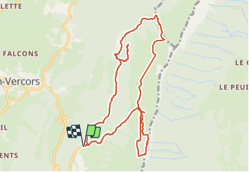

Length
11.6 km

Max alt
1723 m

Uphill gradient
563 m
Km-Effort
19.1 km

Min alt
1374 m

Downhill gradient
564 m
Boucle
Yes
Creation date :
2023-08-10 08:06:01.165
Updated on :
2023-08-10 14:23:12.084
3h31
Difficulty : Very difficult

FREE GPS app for hiking
 SityTrail
IGN / Geographical institutes
SityTrail Plus
The world is yours!
About
Trail Walking of 11.6 km to be discovered at Auvergne-Rhône-Alpes, Isère, Lans-en-Vercors. This trail is proposed by panetJeanLuc.
Positioning
Country:
France
Region :
Auvergne-Rhône-Alpes
Department/Province :
Isère
Municipality :
Lans-en-Vercors
Location:
Unknown
Start:(Dec)
Start:(UTM)
705242 ; 4999171 (31T) N.
Comments