


St Sorlin vers Pravel

jeanboulay
User
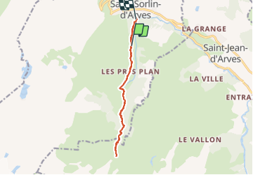

Length
13.6 km

Max alt
1796 m

Uphill gradient
401 m
Km-Effort
19.4 km

Min alt
1495 m

Downhill gradient
542 m
Boucle
No
Creation date :
2023-08-09 09:24:34.148
Updated on :
2023-08-10 16:02:06.33
3h15
Difficulty : Medium

FREE GPS app for hiking
 SityTrail
IGN / Geographical institutes
SityTrail Plus
The world is yours!
About
Trail Walking of 13.6 km to be discovered at Auvergne-Rhône-Alpes, Savoy, Saint-Sorlin-d'Arves. This trail is proposed by jeanboulay.
Description
Rando facile aller retour..
Positioning
Country:
France
Region :
Auvergne-Rhône-Alpes
Department/Province :
Savoy
Municipality :
Saint-Sorlin-d'Arves
Location:
Unknown
Start:(Dec)
Start:(UTM)
282255 ; 5009848 (32T) N.
Comments