


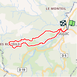
les roudils

raab
User

Length
7.4 km

Max alt
651 m

Uphill gradient
269 m
Km-Effort
11 km

Min alt
396 m

Downhill gradient
267 m
Boucle
Yes
Creation date :
2018-07-30 16:23:39.342
Updated on :
2018-07-30 16:23:39.35
2h46
Difficulty : Easy

FREE GPS app for hiking
 SityTrail
IGN / Geographical institutes
SityTrail Plus
The world is yours!
About
Trail Walking of 7.4 km to be discovered at Auvergne-Rhône-Alpes, Ardèche, Jaujac. This trail is proposed by raab.
Positioning
Country:
France
Region :
Auvergne-Rhône-Alpes
Department/Province :
Ardèche
Municipality :
Jaujac
Location:
Unknown
Start:(Dec)
Start:(UTM)
599787 ; 4943467 (31T) N.
Comments