


2023-08-11_14h09m49_SityTrail - 3384218 - proussy (1)

Houel
User
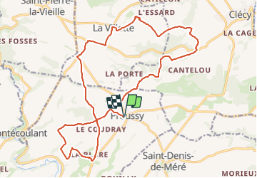

Length
21 km

Max alt
254 m

Uphill gradient
536 m
Km-Effort
28 km

Min alt
77 m

Downhill gradient
538 m
Boucle
Yes
Creation date :
2023-08-11 12:09:49.362
Updated on :
2023-08-11 12:09:50.053

FREE GPS app for hiking
 SityTrail
IGN / Geographical institutes
SityTrail Plus
The world is yours!
About
Trail of 21 km to be discovered at Normandy, Calvados, Condé-en-Normandie. This trail is proposed by Houel.
Positioning
Country:
France
Region :
Normandy
Department/Province :
Calvados
Municipality :
Condé-en-Normandie
Location:
Proussy
Start:(Dec)
Start:(UTM)
680495 ; 5417435 (30U) N.
Comments