


Balade au dessus du Col de l'Allimas

rapako
User
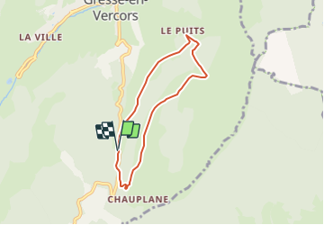

Length
6 km

Max alt
1532 m

Uphill gradient
307 m
Km-Effort
10.2 km

Min alt
1256 m

Downhill gradient
311 m
Boucle
Yes
Creation date :
2023-08-12 08:21:09.632
Updated on :
2023-08-12 08:23:51.37
2h18
Difficulty : Medium

FREE GPS app for hiking
 SityTrail
IGN / Geographical institutes
SityTrail Plus
The world is yours!
About
Trail Walking of 6 km to be discovered at Auvergne-Rhône-Alpes, Isère, Gresse-en-Vercors. This trail is proposed by rapako.
Positioning
Country:
France
Region :
Auvergne-Rhône-Alpes
Department/Province :
Isère
Municipality :
Gresse-en-Vercors
Location:
Unknown
Start:(Dec)
Start:(UTM)
702723 ; 4973013 (31T) N.
Comments