


Chamrousse la pra

fab4u
User
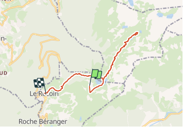

Length
14.4 km

Max alt
2210 m

Uphill gradient
641 m
Km-Effort
25 km

Min alt
1671 m

Downhill gradient
1178 m
Boucle
No
Creation date :
2023-08-12 08:47:09.237
Updated on :
2023-08-12 15:54:33.57
7h02
Difficulty : Very difficult

FREE GPS app for hiking
 SityTrail
IGN / Geographical institutes
SityTrail Plus
The world is yours!
About
Trail Walking of 14.4 km to be discovered at Auvergne-Rhône-Alpes, Isère, Chamrousse. This trail is proposed by fab4u.
Positioning
Country:
France
Region :
Auvergne-Rhône-Alpes
Department/Province :
Isère
Municipality :
Chamrousse
Location:
Unknown
Start:(Dec)
Start:(UTM)
728685 ; 5001507 (31T) N.
Comments