


Troyes Nord Est

DaVinci
User
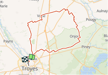

Length
75 km

Max alt
224 m

Uphill gradient
705 m
Km-Effort
85 km

Min alt
95 m

Downhill gradient
706 m
Boucle
No
Creation date :
2023-08-13 08:43:10.453
Updated on :
2023-08-13 10:34:09.835
1h50
Difficulty : Easy

FREE GPS app for hiking
 SityTrail
IGN / Geographical institutes
SityTrail Plus
The world is yours!
About
Trail Moto cross of 75 km to be discovered at Grand Est, Aube, Troyes. This trail is proposed by DaVinci.
Positioning
Country:
France
Region :
Grand Est
Department/Province :
Aube
Municipality :
Troyes
Location:
Unknown
Start:(Dec)
Start:(UTM)
579068 ; 5351486 (31U) N.
Comments