


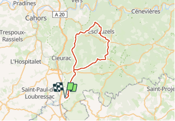
Boucle montdoumerc

Glurps
User

Length
51 km

Max alt
366 m

Uphill gradient
690 m
Km-Effort
60 km

Min alt
166 m

Downhill gradient
690 m
Boucle
Yes
Creation date :
2023-08-13 08:21:25.0
Updated on :
2023-08-13 12:15:19.732

FREE GPS app for hiking
 SityTrail
IGN / Geographical institutes
SityTrail Plus
The world is yours!
About
Trail of 51 km to be discovered at Occitania, Lot, Montdoumerc. This trail is proposed by Glurps.
Photos

Positioning
Country:
France
Region :
Occitania
Department/Province :
Lot
Municipality :
Montdoumerc
Location:
Unknown
Start:(Dec)
Start:(UTM)
381852 ; 4904679 (31T) N.
Comments