


TERNEZE-14-08-23

papou73
User

Length
6.3 km

Max alt
778 m

Uphill gradient
232 m
Km-Effort
9.4 km

Min alt
556 m

Downhill gradient
231 m
Boucle
Yes
Creation date :
2023-08-14 11:38:42.371
Updated on :
2023-08-14 11:41:26.119
2h08
Difficulty : Medium

FREE GPS app for hiking
 SityTrail
IGN / Geographical institutes
SityTrail Plus
The world is yours!
About
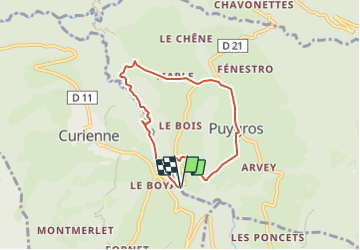
Trail Walking of 6.3 km to be discovered at Auvergne-Rhône-Alpes, Savoy, Puygros. This trail is proposed by papou73.
Description
Canyon de la Ternèze depuis le pont de BOYAT, Puygros, Marlele trou de l'Enfer.
Positioning
Country:
France
Region :
Auvergne-Rhône-Alpes
Department/Province :
Savoy
Municipality :
Puygros
Location:
Unknown
Start:(Dec)
Start:(UTM)
267812 ; 5049463 (32T) N.
Comments