


boucle Gondrecourt Vouthon-Haut

CDSM 55
User
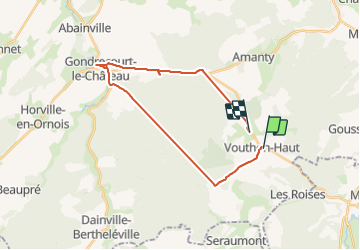

Length
23 km

Max alt
444 m

Uphill gradient
293 m
Km-Effort
27 km

Min alt
294 m

Downhill gradient
327 m
Boucle
No
Creation date :
2023-08-14 13:50:30.948
Updated on :
2023-08-14 15:44:40.008
1h01
Difficulty : Medium

FREE GPS app for hiking
 SityTrail
IGN / Geographical institutes
SityTrail Plus
The world is yours!
About
Trail Road bike of 23 km to be discovered at Grand Est, Meuse, Vouthon-Haut. This trail is proposed by CDSM 55.
Description
reco pour l'OT
Photos


Positioning
Country:
France
Region :
Grand Est
Department/Province :
Meuse
Municipality :
Vouthon-Haut
Location:
Unknown
Start:(Dec)
Start:(UTM)
693493 ; 5372536 (31U) N.
Comments