


custines malleloy faulx

Titinechris
User
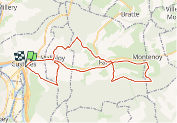

Length
19.1 km

Max alt
394 m

Uphill gradient
540 m
Km-Effort
26 km

Min alt
191 m

Downhill gradient
535 m
Boucle
Yes
Creation date :
2023-08-15 12:07:47.314
Updated on :
2023-08-15 12:07:48.306
5h58
Difficulty : Medium

FREE GPS app for hiking
 SityTrail
IGN / Geographical institutes
SityTrail Plus
The world is yours!
About
Trail Walking of 19.1 km to be discovered at Grand Est, Meurthe-et-Moselle, Custines. This trail is proposed by Titinechris.
Positioning
Country:
France
Region :
Grand Est
Department/Province :
Meurthe-et-Moselle
Municipality :
Custines
Location:
Unknown
Start:(Dec)
Start:(UTM)
290194 ; 5408003 (32U) N.
Comments