


230815 rode saint Agathe

naviglioteca
User
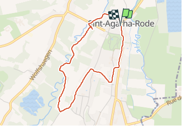

Length
3.7 km

Max alt
62 m

Uphill gradient
48 m
Km-Effort
4.3 km

Min alt
28 m

Downhill gradient
49 m
Boucle
Yes
Creation date :
2023-08-15 11:16:56.415
Updated on :
2023-08-15 12:08:56.481
51m
Difficulty : Easy

FREE GPS app for hiking
 SityTrail
IGN / Geographical institutes
SityTrail Plus
The world is yours!
About
Trail Walking of 3.7 km to be discovered at Flanders, Flemish Brabant, Huldenberg. This trail is proposed by naviglioteca.
Positioning
Country:
Belgium
Region :
Flanders
Department/Province :
Flemish Brabant
Municipality :
Huldenberg
Location:
Sint-Agatha-Rode
Start:(Dec)
Start:(UTM)
615162 ; 5627373 (31U) N.
Comments