


2023 08 16 Aubusson

chlafaille
User

Length
13 km

Max alt
461 m

Uphill gradient
224 m
Km-Effort
16 km

Min alt
396 m

Downhill gradient
227 m
Boucle
Yes
Creation date :
2023-08-16 12:02:03.063
Updated on :
2023-08-16 15:04:12.483
3h01
Difficulty : Medium

FREE GPS app for hiking
 SityTrail
IGN / Geographical institutes
SityTrail Plus
The world is yours!
About
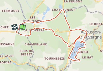
Trail Walking of 13 km to be discovered at Auvergne-Rhône-Alpes, Puy-de-Dôme, Aubusson-d'Auvergne. This trail is proposed by chlafaille.
Positioning
Country:
France
Region :
Auvergne-Rhône-Alpes
Department/Province :
Puy-de-Dôme
Municipality :
Aubusson-d'Auvergne
Location:
Unknown
Start:(Dec)
Start:(UTM)
544650 ; 5066988 (31T) N.
Comments