


Télégraphe-Le Col

nicolas54230
User
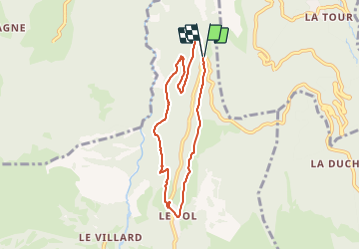

Length
7.1 km

Max alt
1647 m

Uphill gradient
386 m
Km-Effort
12.3 km

Min alt
1290 m

Downhill gradient
387 m
Boucle
Yes
Creation date :
2023-08-17 11:18:36.585
Updated on :
2023-08-17 11:19:36.899
2h47
Difficulty : Easy

FREE GPS app for hiking
 SityTrail
IGN / Geographical institutes
SityTrail Plus
The world is yours!
About
Trail On foot of 7.1 km to be discovered at Auvergne-Rhône-Alpes, Savoy, Valloire. This trail is proposed by nicolas54230.
Positioning
Country:
France
Region :
Auvergne-Rhône-Alpes
Department/Province :
Savoy
Municipality :
Valloire
Location:
Unknown
Start:(Dec)
Start:(UTM)
299296 ; 5008656 (32T) N.
Comments
Chaussures de marche conseillées: passages dans des pierriers pentus.