


rando lac de Constance 1

Tommy Eric
User

Length
11.3 km

Max alt
497 m

Uphill gradient
190 m
Km-Effort
13.8 km

Min alt
397 m

Downhill gradient
187 m
Boucle
Yes
Creation date :
2023-08-17 10:08:44.033
Updated on :
2023-08-17 13:41:51.906
3h32
Difficulty : Difficult

FREE GPS app for hiking
 SityTrail
IGN / Geographical institutes
SityTrail Plus
The world is yours!
About
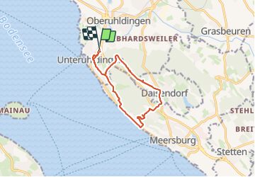
Trail Walking of 11.3 km to be discovered at Baden-Württemberg, Bodenseekreis, Uhldingen-Mühlhofen. This trail is proposed by Tommy Eric.
Positioning
Country:
Germany
Region :
Baden-Württemberg
Department/Province :
Bodenseekreis
Municipality :
Uhldingen-Mühlhofen
Location:
Unknown
Start:(Dec)
Start:(UTM)
517703 ; 5285700 (32T) N.
Comments