


2023 08 18 Chalmazel Olmet (3)

chlafaille
User
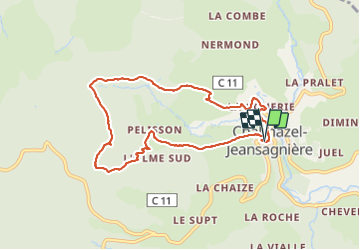

Length
8.2 km

Max alt
1217 m

Uphill gradient
341 m
Km-Effort
12.7 km

Min alt
874 m

Downhill gradient
335 m
Boucle
Yes
Creation date :
2023-08-18 12:36:26.261
Updated on :
2023-08-18 14:52:44.184
2h15
Difficulty : Medium

FREE GPS app for hiking
 SityTrail
IGN / Geographical institutes
SityTrail Plus
The world is yours!
About
Trail Walking of 8.2 km to be discovered at Auvergne-Rhône-Alpes, Loire, Chalmazel-Jeansagnière. This trail is proposed by chlafaille.
Positioning
Country:
France
Region :
Auvergne-Rhône-Alpes
Department/Province :
Loire
Municipality :
Chalmazel-Jeansagnière
Location:
Chalmazel
Start:(Dec)
Start:(UTM)
566176 ; 5061355 (31T) N.
Comments