


Col de Lestard

Nono55
User
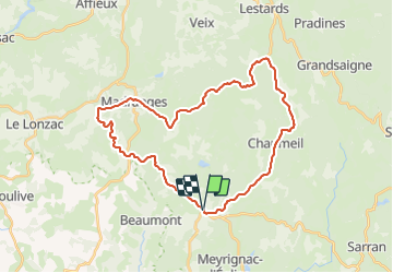

Length
34 km

Max alt
851 m

Uphill gradient
610 m
Km-Effort
42 km

Min alt
508 m

Downhill gradient
610 m
Boucle
Yes
Creation date :
2023-08-19 08:08:52.0
Updated on :
2023-08-19 10:14:02.864
1h41
Difficulty : Medium

FREE GPS app for hiking
 SityTrail
IGN / Geographical institutes
SityTrail Plus
The world is yours!
About
Trail Road bike of 34 km to be discovered at New Aquitaine, Corrèze, Saint-Augustin. This trail is proposed by Nono55.
Description
Toujours aussi belle la Corrèze monte agréable à l ombre
Positioning
Country:
France
Region :
New Aquitaine
Department/Province :
Corrèze
Municipality :
Saint-Augustin
Location:
Unknown
Start:(Dec)
Start:(UTM)
408907 ; 5030899 (31T) N.
Comments