


réserve naturelle de Lierneux

Chanchan63
User
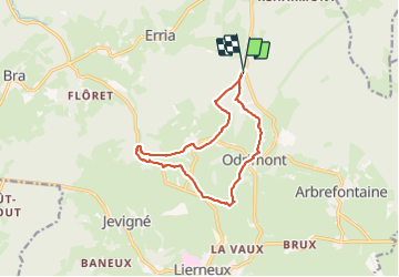

Length
11.2 km

Max alt
473 m

Uphill gradient
194 m
Km-Effort
13.8 km

Min alt
332 m

Downhill gradient
196 m
Boucle
Yes
Creation date :
2023-08-19 12:41:11.612
Updated on :
2023-08-20 08:30:39.664
3h29
Difficulty : Very easy

FREE GPS app for hiking
 SityTrail
IGN / Geographical institutes
SityTrail Plus
The world is yours!
About
Trail Walking of 11.2 km to be discovered at Wallonia, Liège, Lierneux. This trail is proposed by Chanchan63.
Description
Jolie petite balade en compagnie de Lucky
Photos


27 photos in total. Please click on a photo to see them all in the gallery.
Positioning
Country:
Belgium
Region :
Wallonia
Department/Province :
Liège
Municipality :
Lierneux
Location:
Unknown
Start:(Dec)
Start:(UTM)
699633 ; 5578486 (31U) N.
Comments