


st cyprien les monges. St cyprien plage . St cyprien port . capellans . retour les monges

stef789
User GUIDE
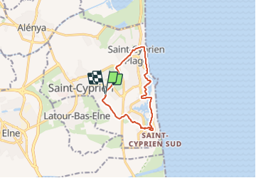

Length
10.7 km

Max alt
9 m

Uphill gradient
44 m
Km-Effort
11.2 km

Min alt
-2 m

Downhill gradient
45 m
Boucle
Yes
Creation date :
2023-08-20 09:58:18.704
Updated on :
2023-08-20 12:34:41.811
2h20
Difficulty : Easy

FREE GPS app for hiking
 SityTrail
IGN / Geographical institutes
SityTrail Plus
The world is yours!
About
Trail Walking of 10.7 km to be discovered at Occitania, Pyrénées-Orientales, Saint-Cyprien. This trail is proposed by stef789.
Photos


Positioning
Country:
France
Region :
Occitania
Department/Province :
Pyrénées-Orientales
Municipality :
Saint-Cyprien
Location:
Unknown
Start:(Dec)
Start:(UTM)
501338 ; 4718113 (31T) N.
Comments