


2023 08 20 col du Béal

chlafaille
User

Length
9.3 km

Max alt
1539 m

Uphill gradient
343 m
Km-Effort
13.9 km

Min alt
1255 m

Downhill gradient
343 m
Boucle
Yes
Creation date :
2023-08-20 11:41:36.527
Updated on :
2023-08-20 14:13:04.448
2h30
Difficulty : Medium

FREE GPS app for hiking
 SityTrail
IGN / Geographical institutes
SityTrail Plus
The world is yours!
About
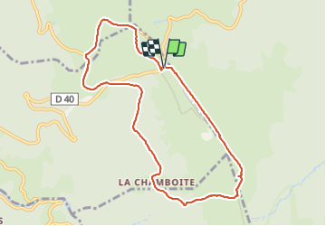
Trail Walking of 9.3 km to be discovered at Auvergne-Rhône-Alpes, Puy-de-Dôme, Saint-Pierre-la-Bourlhonne. This trail is proposed by chlafaille.
Positioning
Country:
France
Region :
Auvergne-Rhône-Alpes
Department/Province :
Puy-de-Dôme
Municipality :
Saint-Pierre-la-Bourlhonne
Location:
Unknown
Start:(Dec)
Start:(UTM)
560990 ; 5059390 (31T) N.
Comments