


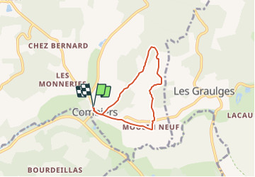
Randonnée Combiers -le moulin neuf- les Bernouilies

alainjoseph6
User

Length
5.1 km

Max alt
167 m

Uphill gradient
85 m
Km-Effort
6.2 km

Min alt
96 m

Downhill gradient
85 m
Boucle
Yes
Creation date :
2023-08-21 09:21:13.821
Updated on :
2023-08-21 09:21:13.821
1h24
Difficulty : Medium

FREE GPS app for hiking
 SityTrail
IGN / Geographical institutes
SityTrail Plus
The world is yours!
About
Trail Walking of 5.1 km to be discovered at New Aquitaine, Charente, Combiers. This trail is proposed by alainjoseph6.
Description
Au départ de Combiers vers le moulin neuf - passage par le Pieux - les Bernouillies - le Dolmen et retour vers Combiers
Positioning
Country:
France
Region :
New Aquitaine
Department/Province :
Charente
Municipality :
Combiers
Location:
Unknown
Start:(Dec)
Start:(UTM)
297985 ; 5040959 (31T) N.
Comments