Trail Equestrian Theizé - THEIZE Poerres Dorées - Photo

THEIZE Poerres Dorées

 azipat
azipat

User

© OpenStreetMap contributors
Length
Length
32 km
Max alt
Max alt
866 m
Uphill gradient
Uphill gradient
1108 m
Km-Effort
Km-Effort  
47 km
Min alt
Min alt
354 m
Downhill gradient
Downhill gradient
1107 m
Boucle
Boucle
Yes
Creation date :
2018-03-24 00:00:00.0
Updated on :
2018-03-24 00:00:00.0

(0 Reviews)

Equestrian
Equestrian
5h40
Difficulty : Medium

Scan this QR Code to open this trail in the SityTrail application

FREE GPS app for hiking

Logo SityTrail SityTrail

IGN / Geographical institutes

Download SityTrail from the App Store Download SityTrail from Google Play

Logo SityTrail SityTrail World

The world is yours!

Download SityTrail from the App Store Download SityTrail from Google Play Download SityTrail on Huawei AppGallery

About

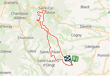
Trail Equestrian of 32 km to be discovered at Auvergne-Rhône-Alpes, Rhône, Theizé. This trail is proposed by azipat.

Description

JE THEIZE Col du Joncin
St Cyr Col du Chatoux 32k364 150117
Mis en ligne par A ChevalRando Libre
Plus de renseignements www.achevalrandolibre.com

Elevation profile

Positioning

Country:
France
Region :
Auvergne-Rhône-Alpes
Department/Province :
Rhône
Municipality :
Theizé
Location:
Unknown
Start:(UTM)
625029 ; 5088619 (31T) N.

Trails nearby

Trail Walking Val d'Oingt - Oingt (69) Beaujolais  - Photo
Walking
Thomasdanielle

Walking

Very easy
(1)
Val d'Oingt, Auvergne-Rhône-Alpes, Rhône, France
9.3 km | 13.3 km-effort
2h 30min
Yes
Trail On foot Légny - De Saint Vérand à Bagnols - Photo
On foot
PRO

On foot

Easy
Légny, Auvergne-Rhône-Alpes, Rhône, France
7.4 km | 10.3 km-effort
2h 20min
No
Trail Nordic walking Bagnols - bagnol - Photo
Nordic walking
isabelle.xavier

Nordic walking

Very easy
(1)
Bagnols, Auvergne-Rhône-Alpes, Rhône, France
6.8 km | 8.4 km-effort
1h 40min
Yes
Trail Electric bike Val d'Oingt - tour dans le beaujolais Oingt - Salles sur Arbuissonnas - Photo
Electric bike
cailloux54

Electric bike

Medium
(1)
Val d'Oingt, Auvergne-Rhône-Alpes, Rhône, France
52 km | 68 km-effort
5h 44min
Yes
Trail Walking Sainte-Paule - Sainte-Paule (13,4 km D. 485 m) - Photo
Walking
Thomasdanielle

Walking

Medium
(1)
Sainte-Paule, Auvergne-Rhône-Alpes, Rhône, France
13.4 km | 19.4 km-effort
4h 9min
Yes
Trail Walking Val d'Oingt - 69620-StLo-160412-Azergues+Genetière+Berthier - Photo
Walking
adye

Walking

Easy
(2)
Val d'Oingt, Auvergne-Rhône-Alpes, Rhône, France
5.2 km | 7.1 km-effort
1h 38min
Yes
Trail Walking Val d'Oingt - Saint-Laurent d'Oingt - Oingt, Plus beau Village de France - Photo
Walking
adye

Walking

Difficult
Val d'Oingt, Auvergne-Rhône-Alpes, Rhône, France
8.8 km | 12.5 km-effort
2h 20min
Yes
Trail Walking Val d'Oingt - 69620-Saint-Laurent d'Oingt-Bois d'Oingt : lavoirs, château et coteaux - Photo
Walking
adye

Walking

Medium
Val d'Oingt, Auvergne-Rhône-Alpes, Rhône, France
8 km | 11 km-effort
1h 57min
Yes
Trail Walking Theizé - Theizé (11 km - D. 310 m) - Photo
Walking
Thomasdanielle

Walking

Medium
Theizé, Auvergne-Rhône-Alpes, Rhône, France
11.3 km | 15.5 km-effort
2h 43min
Yes


Close
My subscriptions