


2023 08 23 Com de la Loge

chlafaille
User
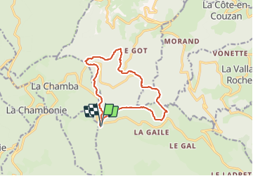

Length
13 km

Max alt
1300 m

Uphill gradient
407 m
Km-Effort
18.4 km

Min alt
1011 m

Downhill gradient
408 m
Boucle
Yes
Creation date :
2023-08-23 07:14:20.245
Updated on :
2023-08-23 10:16:31.743
3h01
Difficulty : Difficult

FREE GPS app for hiking
 SityTrail
IGN / Geographical institutes
SityTrail Plus
The world is yours!
About
Trail Walking of 13 km to be discovered at Auvergne-Rhône-Alpes, Loire, Chalmazel-Jeansagnière. This trail is proposed by chlafaille.
Positioning
Country:
France
Region :
Auvergne-Rhône-Alpes
Department/Province :
Loire
Municipality :
Chalmazel-Jeansagnière
Location:
Jeansagnière
Start:(Dec)
Start:(UTM)
560712 ; 5065664 (31T) N.
Comments